There are few hiking destinations in the world that match the sheer grandeur of Grand Canyon National Park. There is no better way to experience this natural wonder of the world than with your own two feet.
While the beauty of the Grand Canyon hiking trails no doubt possesses a strong pull on visitors to explore the surroundings, this environment can be deceptively challenging, and venturing onto the trails requires respect and preparation.
This hiking guide for Grand Canyon National Park will prepare you for taking on any of its top breathtaking trails. From inner canyon trails to rim trails, and forest trails, spreading out across this immense park’s South and North Rims.
Read on for everything you need to know about the best hiking trails in the Grand Canyon. I’ve broken it into the south rim and the north rim for ease.
Disclosure: This post may contain affiliate links. That means that if you make a purchase through one of those links, I will get a small commission at no extra cost to you.
Best Time to Hike in Grand Canyon National Park
The answer to this question varies depending on which rim you are planning your hike. For North Rim hikes, summer is the best time to hike.
Daytime temperatures are mild, crowds are still relatively low compared to the South Rim, and North Rim facilities are operating in full swing.
North Rim facilities close from mid-October to May each year, with the park roads closing in December (or at the first heavy snow), so it is possible to hike during the shoulder seasons of fall and spring, but preferable to time your hike, for example, in early October or late May.
On the South Rim, you can hike year-round, but there are still considerations for each season. Summer temperatures are moderate enough to enjoy Grand Canyon South Rim hiking trails during the day.
But extreme caution should be exercised if planning to hike down into the inner canyon in summer. Inner canyon hiking is recommended for spring and fall.
Summer on the South Rim also sees the largest amount of crowds, the majority of the several million annual visitors the South Rim sees each year.
Hiking in the Grand Canyon’s South Rim during shoulder seasons and in winter means you will avoid much of the crowds.
Spring and fall are ideal times to enjoy the best hikes in Grand Canyon’s South Rim and North Rim, whether you hike on the rims or in the inner canyon.
Just be sure to note that even in shoulder seasons, for example, early October, temperatures at the bottom of the canyon can still be extreme, so you must absolutely be prepared for hiking in hot weather with plenty of water, hiking essentials, and snacks.
It is recommended to time your inner canyon hikes to be through the bottom portions before the hottest hours of the day.
You can hike at the South Rim in winter, but this desert environment sees a surprising amount of snow, ice, and frigid temperatures, so it is imperative to check the weather before planning a winter hike.
Canyon edges, ice, and hiking don’t tend to mix well. If there is ice or snow present on steep trails, like inner canyon trails, it is recommended not to hike these trails.
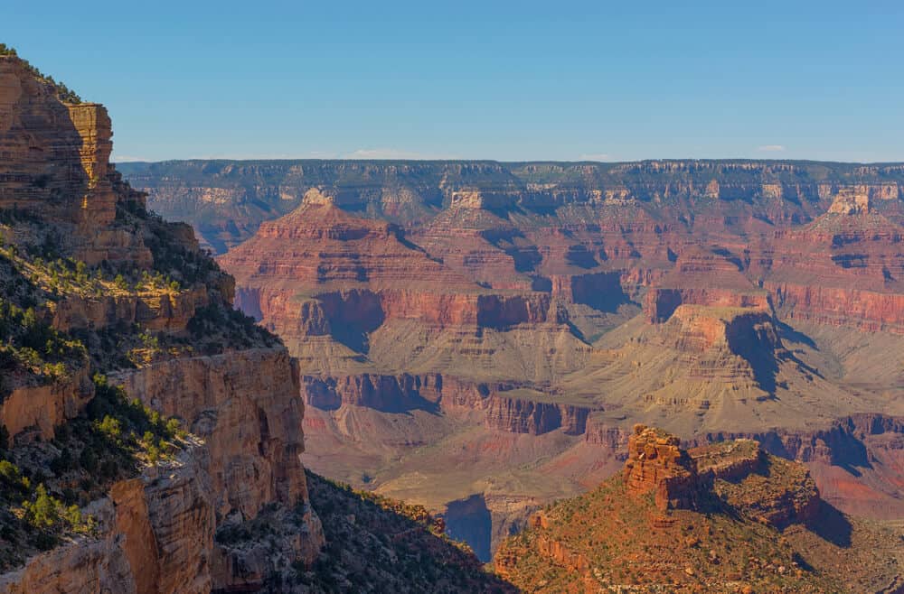
Best hiking trails in the Grand Canyon National Park’s South Rim
The Grand Canyon South Rim hikes boast an overload of epic canyon views, and it is up to you how you want to experience them, whether on rim trails, or inner canyon trails.
While the approach may be different, none of these top trails come up short on breathtaking views. Some just make you work harder for those views, but that is all a part of the reward.
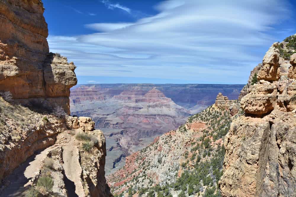
The Bright Angel Trail
Quick Facts on the Bright Angel Trail:
- Length: 19 miles roundtrip out and back
- Rating: Difficult
- Elevation Gain: 4,478 feet
- Estimated Time to Complete: 10-12 hours
When I talk about challenging inner canyon hikes that make you work for the payoff, Bright Angel Trail is the exact definition.
The Bright Angel Trail is arguably the most popular and well-known trail that descends down the Grand Canyon’s South Rim. It offers a solid trifecta of practicality, challenge, and thrill!
The Bright Angel Trail is practical for many hikers because it is easily accessible on the South Rim. It is in close proximity to the Visitor Center, parking lots, lodges, restaurants, and shuttle stops on the free park shuttle.
As for the trail itself, the Bright Angel Trail offers a little dose of help to take the edge off of the intimidation of hiking down and back up the Bright Angel Trail.
The Bright Angel Trail is a very well-maintained, and easy-to-follow trail. It is heavily trafficked, and you typically won’t find yourself hiking alone for long.
There are also multiple water refill stations and bathrooms, never more than a few miles apart from each other.
In a desert environment like the Grand Canyon, this offers relief to many hikers. For those looking for overnight accommodations on the Bright Angel Trail, there are the Havasupai Gardens and Bright Angel Campgrounds.
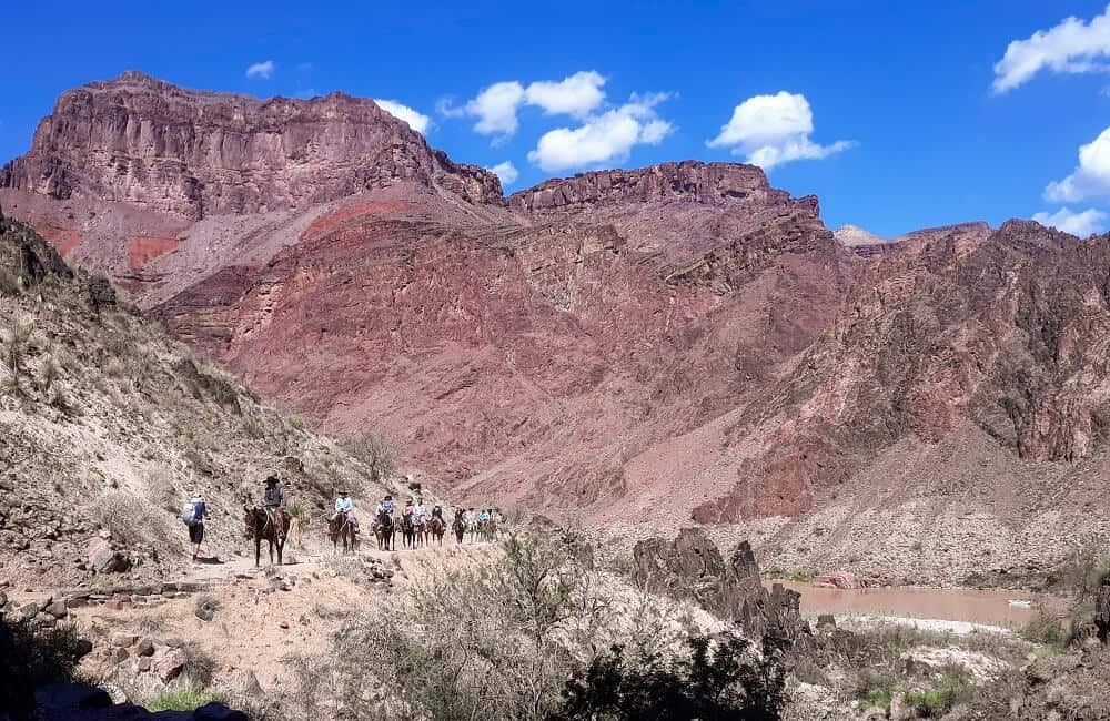
As for the challenge factor, the Bright Angel Trail lives up to its reputation. Those who hike all the way down Bright Angel, to the Colorado River, and then back up to the top of the South Rim, are known as having completed a Rim to River hike, one of the toughest hikes in the country!
With hefty descents and ascents, an elevation gain of almost 4,500 feet, multiple sets of switchbacks, a staggering roundtrip distance of 19 miles, and last but not least, the final climb up the South Rim wall to finish the hike, it is not a challenge to be taken lightly, but there are no words to describe the sense of accomplishment!
Which brings us to the thrill of the Bright Angel Trail. Completing this trail, either in part or in full, is a thrilling reward.
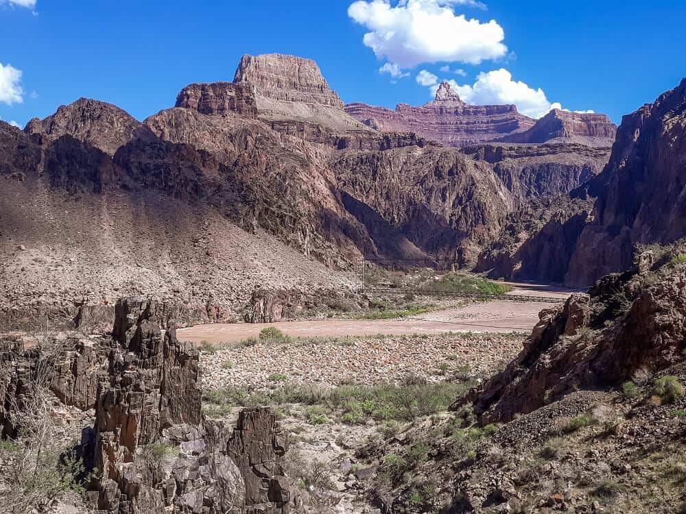
Hikers get to experience the rapid descent of the bronzen South Rim wall, the secret oasis at Havasupai Garden, the winding “Devil’s Corkscrew”, and finally, the sweeping views over the mighty Colorado River at the bottom.
While many millions of visitors get to experience the thrill of the Grand Canyon from atop, only a select few get to experience the indescribable thrill of witnessing the Grand Canyon from the bottom.
The South Kaibab Trail
Quick Facts on the South Kaibab Trail:
- Length: 14 miles roundtrip out and back
- Rating: Difficult
- Elevation Gain: 4,872 feet
- Estimated Time to Complete: 10-12 hours
The South Kaibab Trail is the South Rim “sibling” to the Bright Angel Trail. It also descends the South Rim wall all the way to the Colorado River, but it has a different set of characteristics.
Many would argue, myself included, that the South Rim boasts more stellar views than the Bright Angel Trail. There are multiple vista overlooks, including Ooh Aah Point, Cedar Ridge, and the Tip Off.
The views are undeniably great all the way down to the Colorado River, and the South Kaibab Trail also delivers on the challenge and thrill factor of inner canyon hiking as well!
While this sells many hikers on opting for the South Kaibab Trail, there are also a few important considerations to keep in mind.
First, the South Kaibab Trail is not as easily accessible as the Bright Angel Trail. The trailhead is only accessible by the park shuttle, which runs at designated times, or by private taxi. You cannot park and leave a vehicle at the trailhead.
Second, while the South Kaibab Trail is shorter than the Bright Angel Trail, that inevitably means that it is steeper. This definitely makes both the downhill and uphill more challenging.
Finally, and possibly the most important factor to consider, is that there are NO water sources on the South Kaibab Trail. For this reason alone, especially during the hot summer months, it is not recommended to hike up the South Kaibab Trail.
So what is the solution if you want to hike on the South Kaibab Trail, but want to avoid hiking up? Hike down the South Kaibab Trail to the Colorado River and Bright Angel Campground, where you can pick up the Bright Angel Trail and return up the South Rim on Bright Angel.
Best of both worlds and an answer to experiencing both of these epic South Rim trails in one hiking trip.
The Rim Trail
Quick Facts on the Rim Trail:
- Length: 12.7 miles roundtrip out and back
- Rating: Easy
- Elevation Gain: 583 feet
- Estimated Time to Complete: 5-6 hours
Ready for a South Rim trail that doesn’t require a challenging descent and ascent, without sacrificing any of the views? The Rim Trail is the perfect candidate!
While the Rim Trail’s total of 12.7 miles sounds anything but challenging, it is important to note that you can customize how much of the trail you want to hike.
You can hop on and off at shuttle stops, or you can simply hike to one of many ideal “turnaround” spots along the trail, like Mather Point, Yavapai Point, or Hopi Point.
The Rim Trail runs from Hermits Rest on the west end, to the South Kaibab Trail on the east end, and there are plenty of options in between.
The Rim Trail is predictably named, so expect to hike this trail that parallels the South Rim the entire way.
It is relatively flat, easily accessible from Grand Canyon Village and its Visitor Center, parking, lodges, and amenities, and suitable for families, various ages, and various abilities.
Finally, it offers never-ending views of the Grand Canyon from up above.
The Mather Point Trail
Quick Facts on the Mather Point Trail:
- Length: 0.6 miles roundtrip out and back
- Rating: Easy
- Elevation Gain: 13 feet
- Estimated Time to Complete: 15 – 20 minutes
If you are looking for the best short, easy hike on the South Rim, the Mather Point Trail is the one. If you only have one day at the South Rim of the Grand Canyon, this is ideal for you!
This short and sweet combo trail is perfect for families, those short on time who still want to experience the best canyon views, and those simply looking for a huge effort-to-reward ratio.
The panoramic views here are the evidence, as they are some of the best in the entire park.
It is also convenient that the Mather Point Trail is located right by the South Rim Visitor Center, the heart of Grand Canyon Village, and a congregating location for many visitors and hikers.
You will find plenty of other activities to do and see near the Mather Point Trail, either before or after your hike.
Best North Rim Grand Canyon Hikes
Though the South Rim and North Rim Grand Canyon hikes are all a part of the same National Park, they are worlds apart, literally and figuratively.
The rims are separated by several hours of drive time, and they have completely different looks and feels to them.
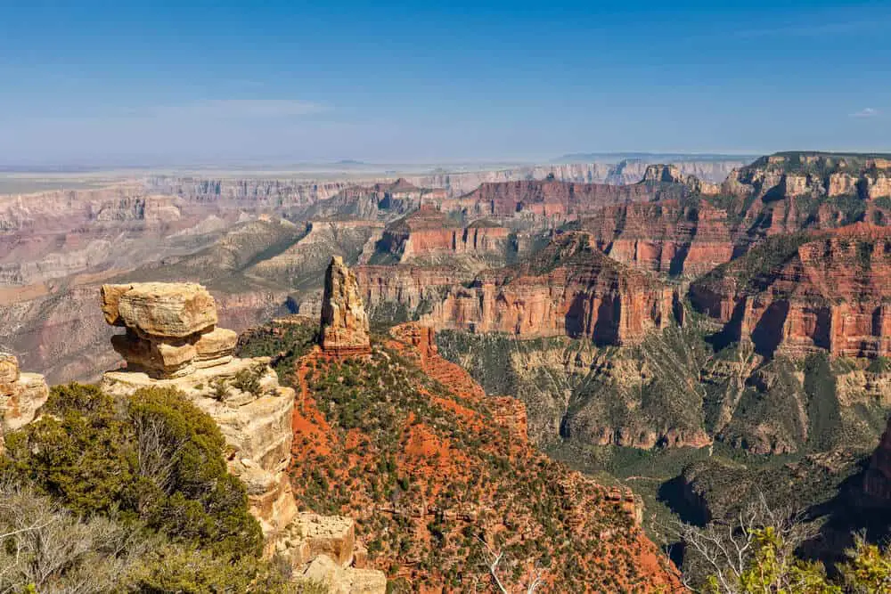
The North Rim is far less trafficked and visited and has a more natural and rustic feel to it. There is also a heavy presence of forest here, mixed in with the stark reds of the canyon walls, and the blazing yellows of the resident aspen trees.
The best hikes in North Rim Grand Canyon capture all the best things of this unique environment on their top hikes.
The North Kaibab Trail
Quick Facts on the North Kaibab Trail:
- Length: 27.4 miles roundtrip out and back
- Rating: Difficult
- Elevation Gain: 6,620 feet
- Estimated Time to Complete: Recommended overnight
As you can probably guess from the name, the North Kaibab Trail is the North Rim counterpart to the South Rim’s South Kaibab Trail. But don’t assume they are the same. The North Kaibab Trail holds its own unique surprises to discover.
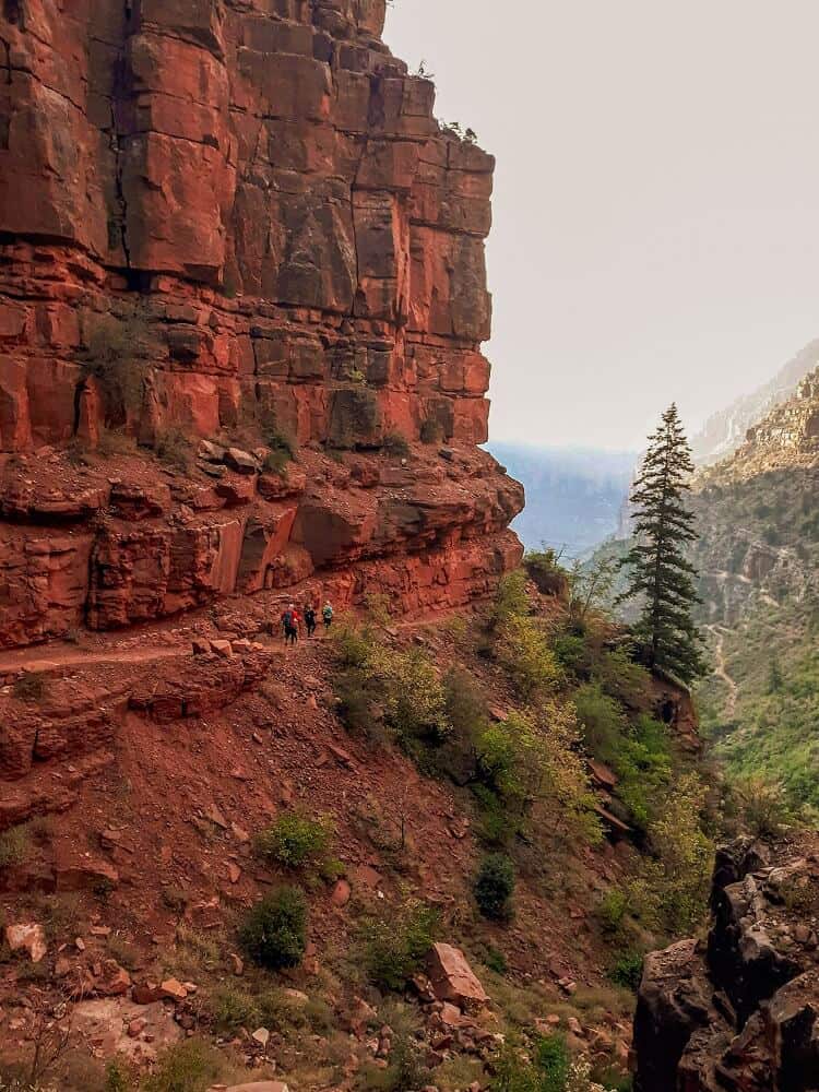
The North Kaibab Trailhead is initially draped in dappled forest, a stark contrast to the open canyon expanses found on the trailheads of the South Rim’s inner canyon trails.
As you descend the North Kaibab Trail, you will encounter the jaw-dropping Coconino Overlook, the Supai Tunnel, cliffside hiking and “subway” tunnels, and even a waterfall – Ribbon Falls.
What many hikers might find most surprising at all, is that once you descend the actual North Rim wall, you don’t immediately arrive at the Colorado River.
Instead, there are miles to go as you traverse the flat, bottom part of the canyon along the North Kaibab Trail.
Here you will find multiple stream crossings, sporadic bursts of lush vegetation, and the Cottonwood Campground, for those looking for overnight camping on the North Kaibab Trail.
It is a surprisingly secret world at the bottom of the Grand Canyon, and the North Kaibab Trail is the best way to experience it.
Finally, the most thrilling moment of the North Kaibab Trail, the arrival at Phantom Ranch, Bright Angel Campground, and the mighty Colorado River.
Did you know you can up the challenge factor and complete a Rim to Rim hike from here? A Rim to Rim hike is a cross-canyon trek from one rim to the other, and the ideal route is from the North Rim to the South Rim.
That means taking the North Kaibab Trail to the bottom, where you can connect to one of the South Rim trails, preferably the Bright Angel Trail.
Simply cross the Colorado River after the North Kaibab Trail, pick up the Bright Angel Trail on the south side of the river, and proceed on with the 2nd half of the Rim to Rim challenge.
Keep in mind a few important things about the North Kaibab Trail. It is the longest trail on this list, with the most elevation gain.
If you do the roundtrip, it is recommended to make it an overnight hike by camping at Cottonwood Campground or Bright Angel Campground.
Be physically prepared and trained for completing the North Kaibab Trail, as climbing up the North Rim wall is extremely steep. There are numerous water refill stations and bathrooms along the way.
The Widforss Trail
Quick Facts on the Widforss Trail:
- Length: 9.3 miles roundtrip out and back
- Rating: Moderate
- Elevation Gain: 1,082 feet
- Estimated Time to Complete: 3.5-5 hours
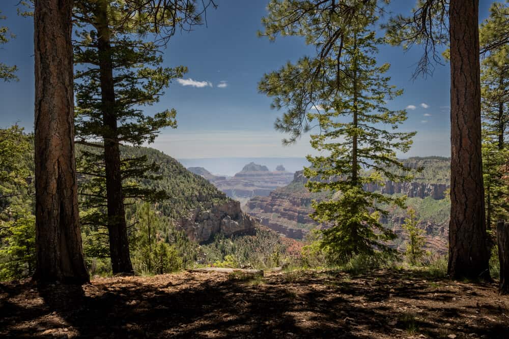
The Widforss Trail is a North Rim favorite for its rim views. While it does not delve into the canyon at all, remaining parallel to the North Rim at all times, it does not skimp on the views.
You can enjoy every inch of the different canyon views from this North Rim perspective, all the while surrounded by welcoming ponderosa pines and shade, with vista overlooks peeking out from the groves.
The other main appeal to the Widforss Trail has to be its great “destination”. A destination hike is a hike whose “turnaround” or “midway point” is an awesome landmark or some other memorable destination.
The Widforss Trail has Widforss Point as its destination, and it is an overwhelming surprise after hiking in forest along much of the trail.
At Widforss Point, the forest dramatically shrinks away to a foreground of canyon plateaus and unobstructed North Rim views.
It is one of the best places on the North Rim to soak in the purples, golds, and reds of the North Rim canyon walls.
The Cape Royal Trail
Quick Facts on the Cape Royal Trail:
- Length: 1-mile roundtrip out and back
- Rating: Easy
- Elevation Gain: 65 feet
- Estimated Time to Complete: 20-30 minutes
The North Rim needs its own easy, family-friendly, top hike too! The Cape Royal Trail is the perfect trail for families and various ages and abilities, due to its short distance, low elevation gain, paved trail, and huge reward waiting for you at the end of Cape Royal Point.
The Cape Royal Trail is unique as it is almost like hiking on a canyon peninsula, which naturally lends to some “suspended” feeling views, surrounding you at the end of Point Royal.
From here, you can see the Colorado River below, as well as the Angel’s Window formation. Enjoy the informational signs posted while you hike, and learn about the unique North Rim environment while you hike.
The Transept Trail
Quick Facts on the Transept Trail:
- Length: 3.7 miles roundtrip out and back
- Rating: Moderate
- Elevation Gain: 347 feet
- Estimated Time to Complete: 1.5-2 hours
The North Rim is characterized and beloved for its wealth of deep forests, so it is natural this list of best trails should include a forest hike!
While the Transept Trail does not contain as impressive of canyon views as some of the other Grand Canyon trails, it still provides some peaceful glimpses, while offering something unique and different.
You can fully appreciate the National Forest on the Transept Trail, which contains ponderosa pines, brilliant aspens, and majestic oaks.
Enjoy whispering breezes, dappled sunlight peeking through the forest canopy, native wildlife like mule deer, and even the remains of some Puebloan ruins
The Transept Trail is practical too, as it connects the North Rim’s Lodge and Visitor Center with the North Rim Campground as well.
Tips for Hiking in Grand Canyon National Park
The Grand Canyon balances between beautiful and dangerous, and in order to fully appreciate its trails responsibly, there are a few tips you should follow for enjoying the best trails in Grand Canyon National Park.
- Stay on Designated Trails
- Always Have Plenty of Water
- Carry All Hiking Essentials
- Don’t Swim in the Colorado River!
- Be Mindful of Flash Floods
- Yield to Oncoming Mules
Reflections on hiking in Grand Canyon
Summed up, there is a myriad of hiking trails in Grand Canyon to choose from for all levels. With its unique nature, it is one of the most impressive National Parks on the West Coast and definitely worthy of your USA bucket list!
Happy travels!