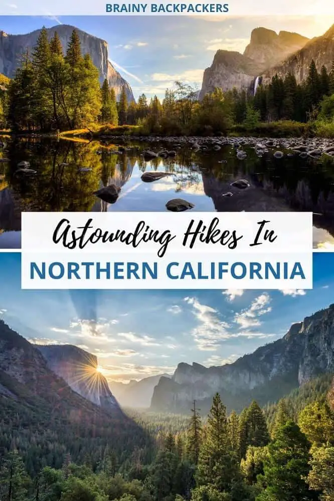
Have you considered hiking in northern California, but are not sure where to start? There are so many amazing hikes in northern California to choose from.
Though the petrifying 2650 miles long Pacific Crest Trail passes through the whole state of California from the south to the north, there are still options for anyone that want to go on a day hike or a multi-day hike without walking for months.
After all, California is home to quite a few of the absolute best national parks on USA’s west coast!
Though the PCT is secretly on my bucket list, I’ll take you through some of the astounding hiking trails in northern California in this post. I got some great help from hikers that have done these trails themselves so that you get all the information you need to confidently conquer new outdoor adventures.
Disclosure: This post may contain affiliate links. That means that if you make a purchase through one of those links, I will get a small commission at no extra cost to you.
What to pack when hiking in northern California
Make sure you don’t forget any of the essentials when you go hiking in northern California. I’ve listed up a few things to think about, but remember to consider the weather and time of year. Dress in layers so you can easily take on and off clothes when needed.
If you’re visiting national parks in winter, make sure you read up on the weather conditions so you’re prepared for what you can expect and which trails are open and not.
I have a complete list of eco friendly backpacks to carry your stuff in here. If you go on a multi-day backpacking trip, check out this eco friendly camping gear checklist. However, if you opt for staying in campgrounds and doing day hikes from there, check out my top picks for instant tents here and the best ones for tenting with dogs here.
- water bottle (make sure you bring Enough water!)
- eco friendly sunscreen
- good hiking boots
- food/snacks (fruit, nuts, dates, etc.)
- caps/hat
- camera
HEADING TO THE EAST COAST?
Beautiful waterfall hikes near Brevard NC
Hikes in Northern California
The national parks on the west coast are some of the finest in the US, and with that comes some of the most scenic hiking trails too.
Whether you’re on a northern California road trip or going on day trips or camping adventures, there are a lot of outdoor adventures to be had in this incredible corner of the US.
Let’s have a look at the top hikes in northern California so you can pick the right one(s) for you!
YOU MIGHT ALSO LIKE
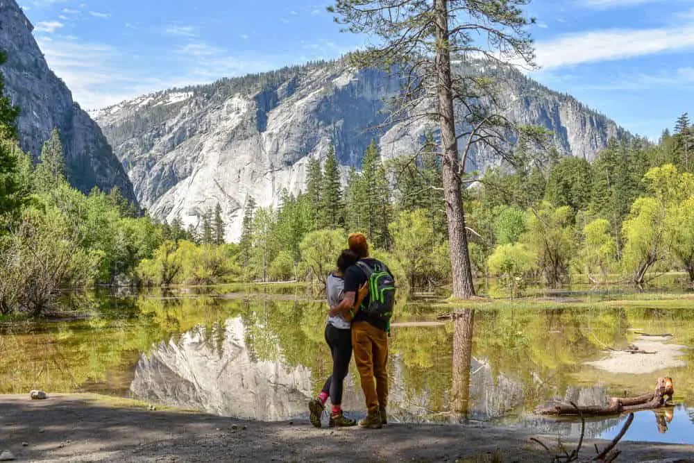
Mirror Lake Loop
By Geena of Beyond The Bucket List
Yosemite National Park is packed with jaw-dropping hikes & scenery and a natural stop on a northern California road trip. This one is no exception. You’ll immerse yourself in the thick forests of the valley floor while hiking alongside a gushing cool blue river.
Surrounded by Yosemite’s iconic jagged peaks the trail takes you through dense underbrush into common bear sighting territory across rocky shale from landslides of long ago.
It’s a diverse landscape and although it lacks some of the “wow” factors of the more popular trails in the park, it has a general peaceful prettiness.
Be sure to hit this hike early in the day if you’re looking to lose the crowds. Personally, my favorite part of this 5-mile loop is the crisp reflections of the surrounding mountains on Mirror Lake. If you catch it in the early morning or evening light, it’s simply breathtaking.
For the most part, the trail is easy – wide flat paths hugging the river’s edge. But in a few spots, the path nearly disappears, leaving you to climb the route of least resistance along the hillside until the path appears again.
Depending on the time of year the path can flood in low elevation places but is still easily passable. Unlike most hikes in Yosemite, there is little elevation gain here & the whole loop should take you around 2-3 hours. To access the trail just head to the North Pines Campground area.
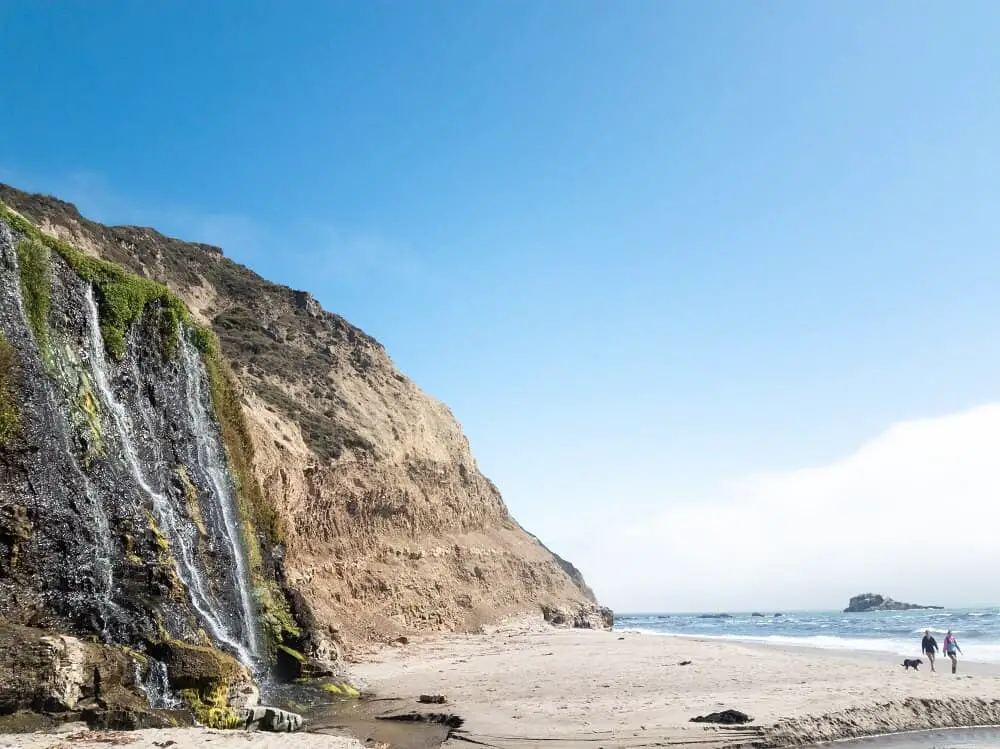
Alamere Falls hike
By Kristel and Gabriel Glasier of Chef Travel Guide
Envision a 40-ft tide fall gushing down over shale cliffs to a sandy beach and spilling onto the Pacific ocean, this is the gem that is waiting for you when you do this beautiful hike in northern California.
About 1.5 hour drive from San Francisco, this popular hike in Point Reyes National Seashore is best visited during the week to avoid the crowds.
There are several trails that lead to this waterfall but the most scenic one is the one from Palomarin trail head via the Coast trail.
This moderate 8.4-mile out and back hike offers sweeping coastal panoramic views, vibrant wildflowers, wooden bridges, freshwater lakes, and rushing creeks.
At the start of this hike you will be walking through fragrant eucalyptus grove while listening to the waves crashing on the jagged rocks.
For the first couple miles, the trail is a bit exposed so it can be warm on a sunny day but you will be treated to an expansive view of the California coastline as sections of the trail hugs the cliffs and drops straight down to the ocean.
This hike takes about 4 to 5 hours to complete and remains fairly flat on most sections with a total elevation gain of about 1083 feet. There is an unofficial “shortcut” to the falls about 4 miles in that is sometimes marked with a left arrow made up of small rocks.
This unmaintained trail is lined with poison oak and involves a steep climb down to the beach. For a safer but longer route, take the Coast Trail to Wildcat campground for a total of 13.8 miles round trip.
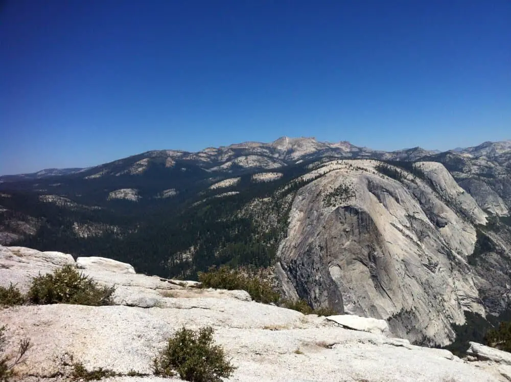
Mist trail to Half Dome
By Eden of Rock a Little Travel
The Mist Trail in Yosemite National Park is one of the most challenging, yet rewarding hikes in northern California, if not the United States.
This out and back hike takes you an approximately 14 miles round trip from Yosemite Valley all the way to the top of Half Dome, a large granite dome that overlooks the park.
The top of Half Dome sits at an elevation of 8,839 feet, and hikers who make it to the top are rewarded with spectacular views of the surrounding valley and High Sierras.
The Mist Trail takes the average hiker anywhere from 10 to 12 hours to complete. This is a strenuous hike that begins with a steep incline, a climb up over 600 granite stairs, a couple of hours of switchbacks, and a steep cable section once you reach the base of the dome. Those with a fear of heights may have difficulty once they reach the cables.
Hikers looking to make the hike to Half Dome will need to obtain a permit in advance. Permits can be obtained by registering for a lottery with the National Park Service beginning in March of every year.
Hikers should plan to begin the Mist Trail around sunrise on the day of the hike. As always, bring a headlamp, good hiking shoes and plenty of water.
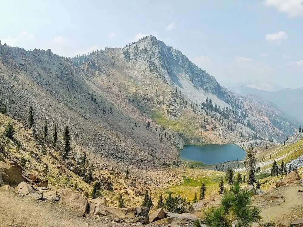
Four Lakes Loop
By Christa of Expedition Wildlife
The Four Lakes Loop in the Trinity Alps of Northern California is the perfect long-weekend hike for overnight backpackers. This stunning, approximately 20-mile round trip trail leads through old-growth forests and alpine meadows, and past waterfalls and pristine lakes.
The overall trip is a lollipop route, where hikers must select one of three possible out-and-back trails to access the Four Lakes Loop. Trails to the loop range from 6- to 8-miles one way, and the Four Lakes Loop itself is six miles around.
Any route taken is still quite arduous, with significant elevation gain and loss over rocky and uneven terrain. Incredible views along the way and at the top of the mountains make the effort worth it!
Consider spending three days and two nights to complete this trek, including one to hike in to the loop, another to complete the Four Lakes Loop, as well as any mountain summit trips, and a third to hike back out to the trail head.
The Trinity Alps Wilderness has specific regulations that overnight hikers should follow, including printing a campfire permit ahead of time and picking up a free wilderness permit at the nearby Weaverville Ranger Station.
All the trail heads are located off of fairly accessible forest roads from Highway 3, a 30-minute drive north of Weaverville Ranger Station.
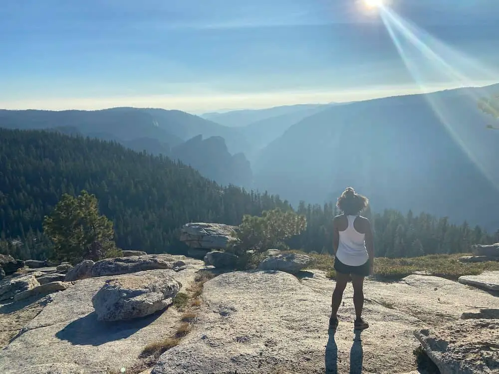
Sentinel Dome
By Ciara of Wellness Travel Diaries
Sentinel Dome is an incredible hike found within the vast Sierra Nevada Mountains. It’s located within the borders of Yosemite, and it’s one of my favorite hikes in Yosemite National Park for a couple of reasons.
First off, this hike is part of a larger trail called the Panorama trail. Known for its iconic beauty, this trail follows the ridge line of the mountains featuring panoramic cliffs and impressive views of famous landmarks within the park.
Some of these views include the infamous Half Dome, Yosemite Falls, and a stunning lookout point on Sentinel Dome.
Secondly, Sentinel Dome offers an impressive 360 degree view of Yosemite. The hike is rated easy to moderate as it follows a flat trail among the giant trees, and then gradually snakes around the mountain when you approach the dome.
Once you reach the base of the dome, it’s a quick scale up the whitish-grey rocks to reach the top and witness the remarkable view.
There are several ways to access this trail head depending on the length of hike you prefer. From the Sentinel Dome trail head it’s 2.2 miles round trip.
However, you can easily extend your hike to include Taft Point, another stop on the Panorama Trail, for a total of 5 miles, which offers incredible views of El Capitan.
For an even longer hike, consider adding Glacier Point. The flexibility of lengthen your hike at any moment is one of the reasons I love this trail!
Don’t forget to pack your camera!
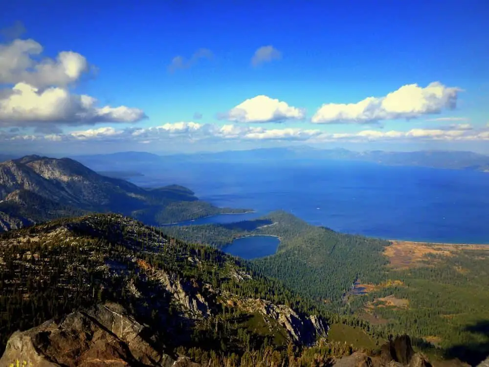
Mount Tallac
By Erin of Curiously Erin
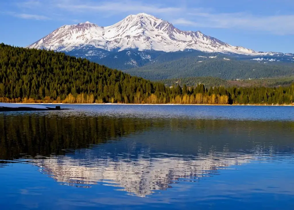
One of the best places to hike in northern California is in the stunning Lake Tahoe area. For those who like a challenge, Mount Tallac is the highest mountain on the shoreline.
Which means you not only get to enjoy hiking through the Sierra Nevada’s, past pristine lakes but also be rewarded with a rare barely obstructed view of Lake Tahoe.
The peak is 9,738 feet high and has an elevation gain of 3,500 feet. You’ll need to allocate a full day for the hike but it’s well worth every minute spent out in the Desolation Wilderness.
It’s a 9 mile in and out track with the majority being in direct sunlight. So plan to start hiking early morning in the summer and bring a hat, sunscreen and plenty of water.
The trail is well marked and easy to follow with a moderate amount of foot traffic. To reach the trail head, you’ll head to the southeastern point of Lake Tahoe near Emerald Bay. Turn down Mount Tallac Road and drive until you reach the end. This is 40 minutes from Tahoe City and 15-20 minutes from South Lake Tahoe.
One of my favourite parts of this hike is the varying landscapes you pass through. Including a break on the summit, the hike takes most people around 6 hours to complete.
During this time you’ll head through fir and pine forests, past Fallen Leaf and Floating Island Lake, over a ridge line, and up the final scree (legs beware). Although you’ll soon forget the burn once you look out over the 360-degree views.
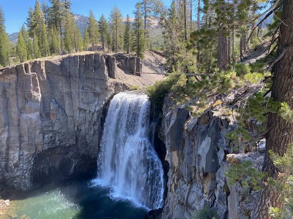
Rainbow Falls Trail
By Wendy of Empty Nesters Hit The Road
Near Mammoth Lakes is the Devil’s Postpile National Monument. And within the monument is one of the best hikes in the Eastern Sierras; the Rainbow Falls Trail.
The trail begins at the Ranger Station and first passes the basalt column rock formation known as Devil’s Postpile. Take the time to climb to the top of the rocks for a great view of the valley below. Then continue on to the falls.
This trail is considered moderately difficult, but if you are coming from a lower elevation, it may feel tougher at times.
I usually advise visitors to this area to allow themselves one day to adjust to the elevation before hiking. Much of the trail follows the San Joaquin River which provides a great scenic backdrop while trekking.
As you approach the end of the trail you can hear the rushing water of Rainbow Falls. The 101 foot falls was named for the rainbow that can often be seen at the base created by the mist. I found this to be a great spot for a picnic lunch. When you’re ready, head back to the Ranger Station.
To reduce traffic in the valley, visitors to the monument are asked to take a tram to and from the Devil’s Postpile National Monument. Tram service is available most days from the Village at Mammoth. This is a very popular trail, so to beat the crowds, head out early.
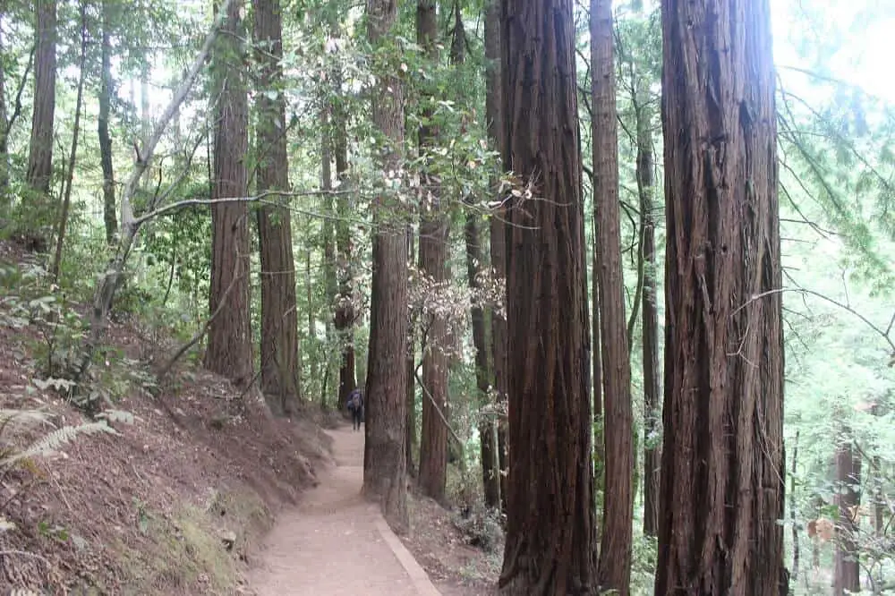
Canopy View Trail in Muir Woods
By Ale of Sea Salt And Fog
Hiking through Muir Woods National Monument is the perfect escape from the hustle and bustle of the Bay Area.
Muir Woods has hikes for every skill level that will still give you stunning views of the redwood forest. A good hike to spend a couple of hours in the park is to take the main trail up to the canopy view trail through the forest, for a 3-hour loop hike with modest elevation gain.
The main trail starts at the Muir Woods entrance and will take you through a grove of giant redwood trees. This is the most leisurely part of the hike through the shady redwoods, with plenty of benches along the way to sit down and take in the scenery.
From the main trail keep an eye out for the canopy view trail – you’ll see the stairs on the right. The main elevation gain of the trail happens here, for about the first mile of the hike.
You’ll continue on Canopy View Trail through the forest until you reach the Lost Trail. The Lost Trail will take you down through the forest until you reach the Fern Creek Trail. The hike down the Lost Trail can be pretty steep and narrow, so watch your step.
The Fern Creek Trail is pretty gentle and flat, and will take you back to the main trail. Altogether, the hike is about 3-4 miles. It’s pretty easy, but bring plenty of water and dress in layers. The weather in Muir Woods is always changing.
Leave no trace on the hiking trails in northern California
It shouldn’t be necessary to mention this, but I so often see rubbish while hiking, even in the most protected areas. I know it’s easy to forget something at your lunch spot or that something flies away with the wind. But if we all take responsibility to check our lunch spot or camp site one extra time before leaving that can help a lot.
Also if you’re hiking in northern California, or anywhere else, pick up if you see any lost pieces of anyone’s lunch pack.
Even organic waste like apple cores needs to come back from your hike. As the seeds from these fruits are not endemic to the area it can be harmful for the existing plants if you as an example grow an apple tree there.
Plus, chances that animals and bugs eat up that piece of organic waste before it turns into soil is pretty big. And by feeding the animals, you can create a pretty terrible chain reaction to the natural food chain and eco system.
And let’s be honest! None of us want that, so let’s simply leave no trace.
Happy hiking!
READ NEXT: Astounding hikes in southern California
Pin it for later!